Essential Question: Why are they called the Black, White, Red, & Yellow Seas?
Black Sea

- Surface Area: 422,000 km2 (163,000 sq mi) (not including the Sea of Azov)
- Average Depth: 1,253 m (4,111 ft)
- Max Depth: 2,200 m (7,200 ft)
Connects to the Mediterranean Sea via the Bosporus Strait, Sea of Marmara, and Dardanelles Strait. The Sea of Azov lies to the northeast (Luhr, 2003, p. 408).
According to Irina Dreyvitser (2014), the Black Sea was originally called the “Inhospitable Sea” by the ancient Greeks due to navigational difficulties and hostile tribes on its shores. Additionally, the most common theories about why it was named the Black Sea include:
Metal objects from ships, dead plants, and animal matter that sunk deeper than 150 meters for a long period of time became covered with a black sludge due to the high concentration of hydrogen sulfide in the sea.
From the perspective of sailors, the sea was black due to severe storms in the winter, during which the water is so dark it looks black.
Others argue that the name has linguistic origins. In Turkish, the Black Sea is called Karadeniz, meaning either the Black Sea or the North Sea. Kara, in Turkish means both the direction north and the color black (Dustin, n.d.).
White Sea

- Surface Area: 90,000 km2 (35,000 sq mi)
- Average Depth: 60 m (200 ft)
- Max Depth: 340 m (1,115 ft)
The continental shelf forms its floor which is broken by troughs and ridges. Inflows are the Barents Sea as well as the Onega and Norther Dvina Rivers. Connected to the Barents Sea through a strait called the Gorlo (“throat”) and the Baltic Sea via canals and Lake Onega. Icebreakers keep the waters navigable throughout the winter providing a crucial economic link to northwestern Russia (Luhr, 2003, p. 400).
Two theories about how the White Sea got its name are:
- The sea is covered with ice for most of the year.
- The water reflects the sky giving it a whitish color.
(Dreyvitser, 2014)
Red Sea
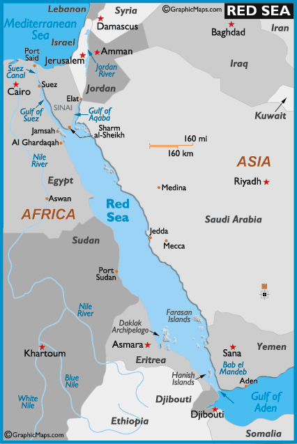
- Surface Area: 450,000 km2 (175,000 sq mi)
- Average Depth: 490 m (1,610 ft)
- Max Depth: 3,040 m (9,975 ft)
Situated between Africa and the Arabian Peninsula, the Red Sea occupies a depression formed by the northern end of the East African Rift. One of the warmest seas in the world, it is also one of the Seven Seas of antiquity (at least according to medieval Europe) (Luhr, 2003, p. 414).
At the northern end lies the Sinai Peninsula which splits the Red Sea into the more shallow Gulf of Suez in the west and the deeper Gulf of Aqaba in the east. In 1869, the Suez Canal opened up allowing maritime traffic to pass to and from the Mediterranean negating the need to go around the Cape of Good Hope. It has no locks due to the Gulf of Suez and the Mediterranean being at the same sea level (Luhr, 2003, p. 414)
The Red Sea is known for its high salinity due to the high temperatures resulting in high evaporation rates and low rainfall (WorldAtlas.com, 2019). Furthermore, there are no major freshwater sources flowing into the Red Sea (Luhr, 2003, p. 414). In contrast to the average seawater salinity of 3.433%, the Red Sea can have a salinity as high as 4.0% (Clark & Stiegeler, 2000, p. 279).
Irina Dreyvitser (2014) notes that “A popular hypothesis about the origins of the Red Sea’s name is that it contains a cyanobacterium called Trichodesmium erythraeum, which turns the normally blue-green water a reddish-brown.” Additionally, sands blowing from the Sahara desert may contribute to the color (Dustin, n.d.).
Alternatively, the name’s origin may be similar to that of the Black Sea. Relative to the Mediterranean Sea, ancient languages used the color red to denote directions. In this case, red corresponded to the direction of the south (Smithsonian Journeys, 2010).
Yellow Sea
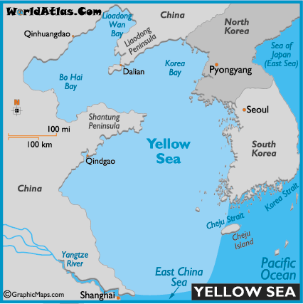
- Surface Area: 530,000 km2 (205,000 sq mi)
- Average Depth: 44 m (144 ft)
- Max Depth: 103 m (338 ft)
The name likely comes from the silt-laden waters discharged from “the Yellow River, the Yangtze, and other major rivers” (Luhr, 2003, p. 419). The Yellow Sea’s floor is predominantly a continental shelf that was either dry or an estuary of the Yellow River about 10,000 years ago. Tides range as much as 8m on the west coast of the Korean Peninsula and surface temperatures can vary from freezing in northern areas during the winter to 82 degrees F (28 degrees C) during the summer in shallow areas (Luhr, 2003, p. 419).
Summary
To answer our essential question, there is no definitive reason why these various seas are named after colors. The answers vary and some are more self-explanatory than others. Sometimes it’s because of regional languages or the environment, but whatever the reason, the name stuck.
References
Clark, J.O.E., & Stiegeler, S. (Eds.). (2000). The Facts on File Dictionary of Earth Science. New York, NY: Market House Books.
Dreyvitser, I. (2014, March 5). Why are The Seas named Black, White, and Yellow?. Retrieved from https://ssec.si.edu/stemvisions-blog/why-are-seas-named-black-white-and-yellow
Dustin. (n.d.). The Four Seas Named After Colors (Or Are They?). Retrieved from http://www.somethinggeography.com/2016/03/the-four-seas-named-after-colors-or-are.html
Luhr, J.F. (Eds.). (2003). Earth. New York, NY: DK Publishing.
Smithsonian Journeys. (2010, May 17). How the Red Sea Got its Name. Retrieved from https://www.smithsonianjourneys.org/blog/how-the-red-sea-got-its-name-180950850/
